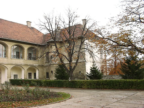
A tér arculatát meghatározó Láncos-kastély 1791-ben, copfstílusban épült. Elnevezését az előtte húzódó, kovácsoltvasból készült lánckerítésről kapta. Építette a Luzsénszky család az 1790-es évek elején. Nevét az elotte húzódó lánckerítésrol kapta. Kivitele egyemeletes, egytraktusos, 16 tengelyes, sátortetos épület. 2 kosáríves, vörösmárvány keretelésu kocsibehajtója van, a bal oldalin 2 címer, a jobb oldalin gótizáló copf ajtószárny. Középen 3 páros oszlopon triglifes párkány hordozta kobábos vörösmárvány erkély. Az épület két végén U alakban hátranyúló rövid szárny helyezkedik el, a belso oldalon hengeres lépcsotornyokkal. |
Address: Mór |
| Openness for the public: |
 2000:11:04 11:43:16 © Mányoki Zsolt |
| Data sheet of the garden |
|
| | |
| Garden identificaton number: | 716 |
| Garden name: | Láncos-kastély és kertje |
| Present size of the garden: | ha |
| Country: | Hungary |
| County: | Fejér |
| Settlement: | Mór |
| Street: | |
| House number: | |
| Phone: | |
| Fax: | |
| Email: | |
| Web site: | www.kastelyok-utazas.hu/Lap.php?cId=557&kId=557http://http://http://http:// |
| WGS84 latitude coordinate: | 47.375453 |
| WGS84 longitude coordinate: | 18.205633 |
| National grid X coordinate: | |
| National grid Y coordinate: | |
| Land ownership record: | |
| Owner: | , , , , |
| Manager(s), renter(s): | , , , , |
| User: | , |
| Present function, usage: | polgármesteri hivatal |
| Openness for the public: | |
| Opening hours: | |
| Visitors per year: | 1990: 1991: 1992: 1993: 1994:
1995: 1996: 1997: 1998: 1999:
2000: 2001: 2002: 2003: 2004:
2005: 2006: 2007: 2008: 2009:
2010: 2011: 2012: 2013: 2014:
2015: 2016: 2017: 2018: 2019:
2020: 2021: 2022: 2023: 2024:
2025: |
| Garden historical data |
|
| Type: | |
| Style, character: | |
| Special value: | |
| Importance, value: | local importance |
| Original size of the garden: | ha |
| Year(s) of garden planting: | -
|
| Present state, condition of the garden: | |
| Present structure of the garden: | |
| : | |
| Plant condition: | |
| Plans, maps: | |
| Historic county name: | |
| Historic Monument Data: |
|
| Historic monument number(s): | 1664 |
| Historic monument type: | műemlék |
| Resolution of historic monument: | |
| Description of built objects |
|
| Main building description: | |
| Building time of the principal building: | |
| Condition of the principal building: | |
| Present function of the main building: | |
| Other buildings list: | |
| Main building style: | |
| Nature Conservation data: |
|
| Type of nature conservation: | |
| Nature Conservation code : | |
| Natuara2000 area code: | |
| Landscape Data: |
|
| Morphology: | |
| Hydrology: | |
| Plant geography: | |
| Soil: | |
| Climate: | |
| Visual connections: | |
| Landscape Character Area name: | |
| Landscape Character Area type: | |
| | |
| Other: | |
| | |
| Associated persons: | |
| Bibliography: | |
| |
| This page edited by: | kollanyi5, |
| Last modified by: | kollanyi5 2009-05-01 |
|


