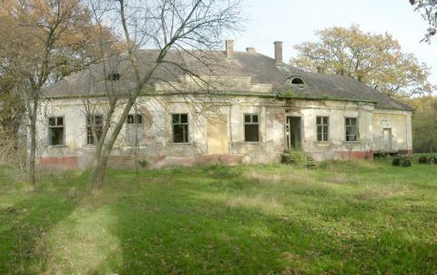
Gencshát a XIX. század első felében vizenyős terület volt, a környék lecsapolása, csatornázása és a földek kiszárítása az 1850-es években történt. A későklasszicista és korai historizáló formaelemeket tartalmazó kastély felépítése az 1860-as évekre tehető. Az épületet minden bizonnyal Návay (IV.) János emeltette, ugyanis az ő ágának tulajdonát képezte a későbbiekben.
Návay (IV.) János 1866-ban bekövetkezett halála után fia Návay (I.) Géza örökölte az épületet és a gencsháti birtokot. A földbirtokos 1919-ben hunyt el, ekkor fiára (II.) Gézára szállt a kastély. Návay (II.) Géza 1925 táján kriptát emeltetett a parkban, apjának földi maradványait akkor ide helyezték át.
Ugyancsak Návay (II.) Géza építtette a kastély parkjában álló kúriát az 1910-es években. A családi hagyomány szerint (II.) Géza egészen apjának haláláig itt lakott.
A földbirtokos Csanád vármegye aljegyzőjeként működött, és visszaemlékezések szerint hosszú ideig agglegényként élt, csak az 1940-es évek elején nősült meg.
A II. világháború után államosították a Návay birtokot, 1947-48 táján a Gencsháti Állami Gazdaság kapta meg, jelenleg pusztulásra van ítélve.
A kúriának a sorsa valamivel biztatóbb, ugyanis a Cecília alapítvány felújíttatta.
Sajnos 2008-ban változott a helyzett. Cikk itt |
Address: Óföldeák (Gencshát) |
| Openness for the public: nem |
 http://www.geocaching.hu |
| Data sheet of the garden |
|
| | |
| Garden identificaton number: | 791 |
| Garden name: | Návay-kastély |
| Present size of the garden: | 3 ha |
| Country: | Hungary |
| County: | Csongrád |
| Settlement: | Óföldeák (Gencshát) |
| Street: | |
| House number: | |
| Phone: | |
| Fax: | |
| Email: | |
| Web site: | www.muemlekem.hu/muemlek?id=12279http://http://http://http://http://http://www.geocaching.hu/caches.geo?id=2216http://http://http:// |
| WGS84 latitude coordinate: | 46.281575 |
| WGS84 longitude coordinate: | 20.396140 |
| National grid X coordinate: | |
| National grid Y coordinate: | |
| Land ownership record: | |
| Owner: | , , , , , , , , |
| Manager(s), renter(s): | , , , , , , , , |
| User: | Cecilía Alapítvány, |
| Present function, usage: | |
| Openness for the public: | nem |
| Opening hours: | |
| Visitors per year: | 1990: 1991: 1992: 1993: 1994:
1995: 1996: 1997: 1998: 1999:
2000: 2001: 2002: 2003: 2004:
2005: 2006: 2007: 2008: 2009:
2010: 2011: 2012: 2013: 2014:
2015: 2016: 2017: 2018: 2019:
2020: 2021: 2022: 2023: 2024:
2025: |
| Garden historical data |
|
| Type: | |
| Style, character: | |
| Special value: | |
| Importance, value: | regional importance |
| Original size of the garden: | ha |
| Year(s) of garden planting: | -
|
| Present state, condition of the garden: | |
| Present structure of the garden: | |
| : | |
| Plant condition: | |
| Plans, maps: | |
| Historic county name: | |
| Historic Monument Data: |
|
| Historic monument number(s): | 12279 |
| Historic monument type: | |
| Resolution of historic monument: | |
| Description of built objects |
|
| Main building description: | |
| Building time of the principal building: | |
| Condition of the principal building: | |
| Present function of the main building: | |
| Other buildings list: | |
| Main building style: | |
| Nature Conservation data: |
|
| Type of nature conservation: | |
| Nature Conservation code : | |
| Natuara2000 area code: | |
| Landscape Data: |
|
| Morphology: | |
| Hydrology: | |
| Plant geography: | |
| Soil: | |
| Climate: | |
| Visual connections: | |
| Landscape Character Area name: | |
| Landscape Character Area type: | |
| | |
| Other: | |
| | |
| Associated persons: | |
| Bibliography: | |
| |
| This page edited by: | kollanyi5, |
| Last modified by: | kollanyi5 2009-05-03 |
|


