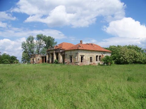
Épült a 19. század elején. A kúria eredetileg az okányi Schwartz földbirtokos családé volt, majd Fried Ignác zsidó földbirtokos tulajdonába került, azzal hogy feleségül vette az örököst Schwartz Bellát. 1943-ban a Magyar Föld Rt. megvette a gazdaságot. A felszabadulás után 1975-ig iskola működött a kastélyban. Ma üresen áll, és romlik az állaga, egy helyen a tető is beszakadt.
Fancsikán található a ma igen rossz állapotban lévő, szinte gazdátlannak mondható, klasszicista stílusban a 19. sz. közepén épült kúria. A kastélyban két-tantermes iskola működött és két tanítói lakás lett kialakítva. A '70-es évek közepén az iskola megszűnt, mivel a lakosság az 1959-es Tsz. szervezés után fogyatkozni kezdett, ráadásul a bolt is bezárt. A területen Tsz. üzemegység is működött. A rendszerváltást követően kárpótlásként felosztották a területet. A jelenlegi állapotra a "romhalmaz" jelző a legjellemzőbb, őrizetlenül, az enyészeté a kúria és a körülvevő terület, pedig teljes közmű van a környező házakban. |
Address: Zsadány (Fancsikapuszta), Fancsikapuszta 83. |
| Openness for the public: |
 2010:05:14 13:24:36 |
| Data sheet of the garden |
|
| | |
| Garden identificaton number: | 1272 |
| Garden name: | Schwartz-Fried kúria és kertje |
| Present size of the garden: | ha |
| Country: | Hungary |
| County: | Békés |
| Settlement: | Zsadány (Fancsikapuszta) |
| Street: | Fancsikapuszta |
| House number: | 83. |
| Phone: | |
| Fax: | |
| Email: | |
| Web site: | www.kastelyok-utazas.hu/Lap.php?cId=982&kId=982http://http://http://http://http://http://http://http://http://http://http://www.geocaching.hu/caches.geo?id=1863http://www.muemlekem.hu/muemlek?id=2624http://http://http:// |
| WGS84 latitude coordinate: | 46.941209 |
| WGS84 longitude coordinate: | 21.541400 |
| National grid X coordinate: | |
| National grid Y coordinate: | |
| Land ownership record: | 1112 |
| Owner: | , , , , , , , , , , , , |
| Manager(s), renter(s): | , , , , , , , , , , , , |
| User: | , |
| Present function, usage: | |
| Openness for the public: | |
| Opening hours: | |
| Visitors per year: | 1990: 1991: 1992: 1993: 1994:
1995: 1996: 1997: 1998: 1999:
2000: 2001: 2002: 2003: 2004:
2005: 2006: 2007: 2008: 2009:
2010: 2011: 2012: 2013: 2014:
2015: 2016: 2017: 2018: 2019:
2020: 2021: 2022: 2023: 2024:
|
| Garden historical data |
|
| Type: | |
| Style, character: | |
| Special value: | |
| Importance, value: | local importance |
| Original size of the garden: | ha |
| Year(s) of garden planting: | -
|
| Present state, condition of the garden: | megsemmisült |
| Present structure of the garden: | |
| : | |
| Plant condition: | gyomos, csak gyep maradt, gondozatlan |
| Plans, maps: | |
| Historic county name: | |
| Historic Monument Data: |
|
| Historic monument number(s): | 814 |
| Historic monument type: | |
| Resolution of historic monument: | |
| Description of built objects |
|
| Main building description: | Volt Fried-kastély, klasszicista, épült az 1870-es években, E alakú, nyugati homlokzata és portikusza oszlopos. 7 szobás. |
| Building time of the principal building: | 1870 körül |
| Condition of the principal building: | romos |
| Present function of the main building: | használaton kívül |
| Other buildings list: | |
| Main building style: | klasszicista |
| Nature Conservation data: |
|
| Type of nature conservation: | |
| Nature Conservation code : | |
| Natuara2000 area code: | |
| Landscape Data: |
|
| Morphology: | |
| Hydrology: | |
| Plant geography: | |
| Soil: | |
| Climate: | |
| Visual connections: | |
| Landscape Character Area name: | |
| Landscape Character Area type: | |
| | |
| Other: | |
| | |
| Associated persons: | |
| Bibliography: | |
| |
| This page edited by: | kollanyi5, Nagy Nikoletta, |
| Last modified by: | Nagy Nikoletta 2010-07-12 |
|


